


HMDA Master Plan 2031
Investing in your dream land or project? Then checkout the HMDA master plan to find out the best area.
Are you looking to purchase land in India? Well, before you do, it’s important to be aware of the rampant scams and fraudulent activities that exist in the Indian real estate market, particularly when it comes to Gram Panchayat layouts.
Many unsuspecting buyers have fallen victim to land disputes and litigation issues that can drag on for years, leading to a land grabbing nightmare.
Unfortunately, the Gram Panchayat layouts are particularly susceptible to these scams, where unscrupulous individuals exploit loopholes and take advantage of unsuspecting buyers
But, there is some good news. You have a safer option available to you – HMDA-approved layouts. HMDA ensures that its layouts undergo rigorous scrutiny before being approved, making them a more secure choice for buyers.
So, let’s take a closer look at HMDA and see how it can help you avoid the pitfalls of land scams.
What Is HMDA?
You might be wondering: What’s behind the remarkable growth of Hyderabad, one of the fastest-growing cities in India?

Well, one factor is the formation of HMDA in 2008, which aims to coordinate, plan, supervise, upgrade, and secure the city’s development.
But that’s not all. Did you know that the HMDA covers an area of around 7,257 sq km, making it the largest development plan in India?
The main intention of this plan is to create better infrastructure facilities and achieve an overall balanced growth of the city.
And how will this be achieved? Through the master plan, which takes into account all future developments and changes. The state government has set this plan in motion, with the ultimate goal of creating a traffic-free city and better infrastructure facilities for the citizens of Hyderabad.
So, get ready to see Hyderabad transform before your eyes!
Background Of HMDA Master Plan 2031
The Hyderabad Master Plan 2031 is a roadmap for the city’s growth, covering an enormous area of 5965 square kilometers in the Hyderabad Metropolitan Region. It anticipates a population of 184 lakhs and takes into account the current development trends, such as the Inner Ring Road, the Outer Ring Road, and highways, to guide Hyderabad’s future growth.
But what makes this plan critical is that it proposes new urban nodes and centers in the region, ensuring balanced development.
The plan also provides guidelines and regulations for building and development activities in Telangana’s Hyderabad Metropolitan Region, managing growth sustainably.
The Hyderabad Metropolitan Development Authority (HMDA) is responsible for implementing the master plan, covering a vast jurisdiction of 55 Mandals in five districts, including Hyderabad, Medak, Rangareddy, Mahbubnagar, and Nalgonda.
This includes the Greater Hyderabad Municipal Corporation, the Sangareddy and Bhongir Municipalities, and 849 villages.
With a clear vision and dedicated authority overseeing its growth, the HMDA Master Plan 2031 sets Hyderabad on a path towards continued success. By considering not only the city’s present needs but also projects for the future, this plan will make Hyderabad a better place to live and work in.
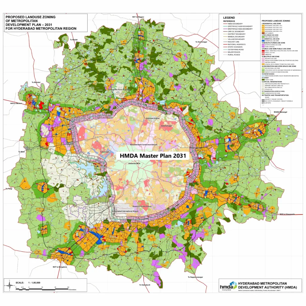
Different Land Use Zones In The HMDA Master Plan
Did you know that the Hyderabad Metropolitan Development Authority (HMDA) has divided the city’s land into 12 different zones based on land use?
This is known as zoning, a method of urban planning used by the government to divide land into areas with specific purposes. And each zone has its own set of regulations governing the density, size, and shape of the buildings allowed, depending on their use.
By specifying outright and conditional uses of land, zoning provides more flexibility in how the land is used. HMDA Land Use Zoning empowers local governments to regulate which areas under their jurisdiction may have real estate or land used for particular purposes.
Here are the 12 Land use zones in the HMDA Master Plan 2031:
- Residential Zone (R1, R2, R3 and R4): Looking for a way to preserve the peaceful character of your neighborhood? Then you’ll want to know about Residential zones. In R-1, R-2, R-3, and R-4 areas, you can enjoy a residential neighborhood without worrying about more intensive multifamily uses or businesses.

But that’s not all, because you might still be able to run a business in these areas if you choose. These zones are designed to strike a balance between residential and commercial uses, giving you the best of both worlds.
But wait, there’s more to learn!
Keep reading this article, because we’re going to dive into the specifics of R-1, R-2, R-3, and R-4 areas in the later sections.
- Peri-Urban Zone: In the Peri-urban zone, there are specific regulations regarding the use of land for construction.
Up to 25% of the land can be used for construction purposes. However, there are restrictions on the height of buildings.
For residential construction, the height is limited to 15 meters, while commercial constructions can go up to 18 meters. Additionally, specific conditions must be met when constructing buildings to ensure compliance with the regulations.
- Commercial Zone: Whether you need a space to set up your business or are looking for a convenient location to meet with clients, this zone has everything you need to succeed.
With its prime location and ample resources, this zone is the perfect choice for anyone looking to make their mark in the world of business.
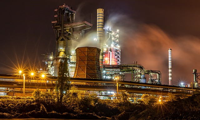
- Manufacturing Zone: When it comes to the Manufacturing Use Zone, there are two distinct types. The first type is the Manufacturing Use Zone, which is reserved solely for industrial developments.
In this zone, residential constructions are strictly prohibited, ensuring that the area remains dedicated to industrial activities.
The second type of zone is the Work Centers, which have been designed in accordance with the Hyderabad Airport Development Authority (HADA) master plan.
- Multiple Zone: Located near the Outer Ring Road, the Multipurpose Zone is a versatile area that offers a wide range of possibilities.
In this zone, all constructions that are permitted in the Residential zones are also allowed, providing great flexibility for developers and investors alike.
The Multipurpose Zone is classified into four categories, each with its unique features and opportunities. These categories include the Multiple Use Zone, Special Development Zone, Central Square, and General Development Promotion Zone (GDPZ).
- Public, Semi-Public Facilities and Utilities Zone: The public and semi-public zone serves a vital purpose in recognizing the importance of facilities and institutions that provide necessary services to the community.
These facilities have their own unique set of circumstances that require a special classification. In fact, the zone is classified into 3 types to better serve the needs of the community.
These types include the public and semi-public facilities and utilities use zone, public utilities, and amenities. By dividing the zone into these types, it becomes easier to ensure that each type receives the attention and resources it requires to continue providing valuable services to the community.
- Forest Zone: Forest zones are dedicated to growing plants and greenery. By design, these zones are intended exclusively for this purpose, which means that any other activities within the area are strictly prohibited.
This ensures that the forest zones are preserved and protected, allowing for the growth and sustainability of the natural environment.

- Water Bodies Zone: In the Water Body Zone, the majority of the area comprises water bodies such as rivers, streams, lakes, tanks, and kuntas.
These bodies of water play an important role in supporting the ecosystem and providing habitats for various species. Within this zone, you can find Himayat Sagar and several other rivers and lakes, which are essential sources of water for the surrounding areas.
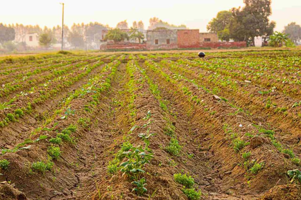
- Agriculture Zone: The Peri-Urban Use Zone is designated as Conservation (Agriculture) Use Zone. Within this zone, the land is used for agricultural purposes, specifically for growing and harvesting crops and raising livestock.
- Traffic and Transportation Zone: Getting from one destination to another can be a challenge without proper transportation.
That’s why we have traffic and transportation zones, which are designed to provide various options for moving around. There are four main categories that fall under this umbrella:
- Roads
- Railways / Railway Stations
- Bus Depots, Passenger / Freight Terminals
- Airports
- Recreation and Open Space Zone: A Recreation Zone is a land that serves a singular purpose: entertainment.
This land could encompass a vast array of activities, such as parks, open spaces, athletic fields, playgrounds, and swimming pools.
- Special Reservations Zone: The Special Reservations zone is a fascinating area that encompasses a variety of important sites.
Among them are the Historic Buildings and Precincts, which are classified as S1. In addition to these, the zone also includes Defense Lands, which fall under the S2 category.
There’s also the Bio Conservation Zone, classified as S3, which is an essential part of the area’s ecological system. Finally, the remaining sites are classified as S4 and include a diverse range of locations that are worth exploring.

What Are Residential Use Zones?
Residential use zones play a vital role in urban planning and land use regulation. They help shape the character and quality of life in a city or town, ensuring that land is used in a way that promotes a safe and healthy living environment.
By designating specific areas for residential use, cities and towns can create peaceful neighborhoods, where residents can feel secure and comfortable in their surroundings.
Residential Use Zone is categorized into four sections(R-1, R-2, R-3, and R-4).
- Residential Zone-1 : Urban areas that reside along the growth corridor, like commercial spaces. It has minimal height restrictions, establishments of 16 floors or up to 18m in height can be constructed.
- Residential Zone-2 : Urban nodes that don’t have any growth options. Height restrictions of 15m-18m apply for all constructions.
Permitted use of R-1& R-2 are same:
- Banks
- All Kinds of Residential Buildings
- Bakeries & Confectioneries
- Auditoriums
- Bus-Depots and stands without Workshops
- Clubs, Community Centers
- Dharamshalas
- Doctors’ Clinics & Dispensaries
- Educational Institutions
- Electricity Distribution Stations
- Fire Stations & Emergency Services
- Gymnasiums,Yoga Centers/Wellness Clinics
- Night Shelters
- Fuel-Filling Pumps
- Police Stations, check posts
- Post Offices
- Water Pumping Stations
- Transit Visitors Camps
- Technical Training Centres
- Central, State & Municipal Government Offices
- Residential Zone-3 : It contains all the remaining urban centers as well as the areas around them. The height restrictions for residential construction are 15m and 18m for non-residential construction.
The permitted and prohibited uses in R3 zones are the same as in R1 and R2 zones, with the exception of the following, which are prohibited in R3.
- Burial/Cremation Grounds
- Bus-Depots
- Cinema Halls
- Clubs
- Computer Software Units
- Electronic Printing Press
- Fire-Stations
- Missionaries
- Health Facilities with max of 20 beds
- Hostels & Boarding Accommodations
- Hotels
- Police Stations
- LPG Distribution Centers.
- Residential Zone-4 : All Rural settlements or Village settlements(Gramkantham) and the existing rural built-up area.
Permitted use of R-4 are :
- Schools
- Religious places
- Restaurants
- Retailing shops
- Repair service centers
- Stables for domestic animals, with a limit of five animals on each plot
- Storage of fodder, crop, agricultural implements.
Planned SEZs
HMDA has identified a few areas that have the potential to be developed as SEZs in the future. Some of the planned SEZ (Special Economic Zone) developments in and around Hyderabad are:
- The Outer Ring Road area: Due to its proximity to the international airport and availability of land, it has potential for the development of IT/ITES and electronic industries on around 2,400 acres.
- Adibatla SEZ: It covers an area of 1,500 acres and focuses on the development of the aerospace and precision engineering industries.
- Pharma City SEZ: It is mainly focused on the developments of the pharmaceutical and biotechnology industries by using 8,000 acres.
- Apparel Park SEZ: It is focused on the textile and apparel industries and covers 1,000 acres.
What Is HMDA Approval?
Are you planning a real estate project or layout development? Then you need to know about the crucial process of obtaining HMDA approval.
But what exactly does this process involve? First, you’ll need to submit an application to HMDA along with all the necessary documents and plans.
But that’s just the beginning.
Next, HMDA officials will review your application and conduct site inspections to ensure that your project complies with all relevant rules and regulations.
This is a thorough process, but it’s necessary to ensure the safety and legality of your project.
So what’s the solution? Once your project is approved, it will be listed on the HMDA website for public view and download.
This means that developers and buyers can access valuable information about land use and regulations for specific areas, allowing them to make informed decisions and ensuring that everyone is following the rules.
Understanding HMDA LRS
Are you a property owner with unauthorized layouts or plots in the HMDA jurisdiction? If yes, then the Layout Regularisation Scheme (LRS) by HMDA can help you.
This scheme provides a one-time opportunity to get your unapproved plots or layouts regularized by paying a certain fee.
But that’s not all; regularizing your property through this scheme is also useful to avoid any future legal complications. You can rest assured that your property is now legal and compliant.
However, it’s important to note that the HMDA LRS scheme has a limited period of validity. Therefore, it’s crucial to apply for it within the specified time frame.
Don’t miss this opportunity to get your property regularized! Once the scheme is approved, you will be updated with an LP number for your layout, providing you with peace of mind.
FAQ’s
What is the difference between GP layout and HMDA layout?
GP layouts are approved by the village administration while HMDA layouts have specific land-use plans for residential or commercial purposes. GP layouts have mixed land-use plans for agricultural, residential, and commercial purposes.
What is the difference between RERA and HMDA?
RERA is a national-level regulatory authority to regulate the real estate sector across India, and its primary function is to protect the interests of home buyers, whereas HMDA is a regional planning and development authority responsible for regulating land use and development in Hyderabad.
What are the list of Mandals covered in the HMDA Master Plan?
Here is the list of Mandals covered under the HMDA Master Plan 2031:
Bibinagar
Bommalaramaram
Buvanagiri
Chevella
Choutuppal
Farooqnagar
Ghatkesar
Hatnura
Hayathnagar
Ibrahimpatnam Manchal
Jinnawaram
Kandukur
Kisara
Kothuru
Maheshwaram
Medchal_Qutubullapur
Moinabad_Rajendranagar
Mulug
Narsapur
Patancheru
Pochampalli
Sangareddy
Shahbad
Shamirpet
Shamshabad
Shankarpalli Ramachandrapuram
Shivampet
Tupran
Wargal
Yacharam
What is the use of a land use certificate?
It is useful to ensure that the proposed land use is in compliance with the local development plan and zoning regulations, and to prevent any unauthorized or illegal use of land.
What is a Free Zone Land?
Free zones are special economic zones that offer tax benefits to companies, and are designed to encourage economic activity. Businesses operating in these zones are taxed lightly or not at all, making them a popular option for expanding into new markets.
How do I find HMDA LP number?
You can find the HMDA LP numbers on the official website (https://www.hmda.gov.in/) under Online Services > BPMS. Enter the land details in the search form, including survey number and village name, and search to find the LP number for approved layouts.
What is the difference between HMDA and DTCP?
DTCP and HMDA operate under RERA guidelines, but have differences in limits and plot prices. HMDA operates in Hyderabad and its plots can be pricier due to proximity to the city, while DTCP operates across the country and its plots may be more affordable.